RO Climate Data
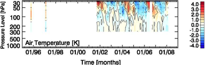
We provide two radio occultation (RO) data sets. The RO method is a remote sensing technique making use of GPS signals to retrieve atmospheric parameters (refractivity, pressure, geopotential height, temperature) in the upper troposphere-lower stratosphere (UTLS), which we define as region between around 5km and 35km height.
The data, atmospheric monthly means, is given at
9 height levels (between 8.5 km to 28 km height),
18 latitudes (90°N to 90°S, 10° steps), and
96 months (intermittently 2001 to 2008, see below).
Temperature and refractivity data are provided. Refractivity can be thought of as atmospheric density and is approximately indirectly proportional to temperature. The data are provided from the Wegener Center for Climate and Global Change, University of Graz.
The sonification shall allow hearing the QBO (Quasi biennial oscillation), a stratospheric pattern of changing temperatures (wind directions), best pronounced in the tropics (10°N–10°S). An extra-tropical QBO signal can be probably found at higher latitudes with a different phase.
For sound examples download the RO_sound_examples.zip file with readme, further informations to be found in the teams' information.
